Finding an old map offers a particular kind of thrill — the sense that you’ve stumbled into a different world, one where adventure awaits.
Now imagine a whole library full of maps.
For first‑timers at UC Berkeley’s Earth Sciences & Map Library, the experience can be electric.
“There’s this quality that’s like, ‘Oh, I’m touching something original,’” said Karen Pfeffer, the library’s circulation supervisor and technical processing assistant. “‘It’s not something I’ve been reading about in a book or a reproduction. It’s the real thing.’”
For Susan Powell, the geographic information systems (GIS) and map librarian, that spark of discovery can lead students to reframe their understanding of maps, both old and new, not as objective pictures of a place but as subjective artifacts, shaped by choices about what to include and emphasize.
“Being able to expose students to the different stories that are told by maps can be so rewarding,” she said. “It’s often a kind of aha moment for them.”
For readers ready for their own aha moment, Pfeffer and Powell selected five throwback maps of particular interest to the Berkeley community. From a hand-lettered tree survey to a whimsical depiction of local businesses, each map captures a distinct version of the campus and city: what was, what might have been, and what Berkeley has always been becoming.

1. Tree huggers, rejoice
This 1910 campus map is a love letter to trees. Likely hand-drawn and almost certainly hand-lettered, it charts the leafy landscape of a budding UC Berkeley with botanical precision. Created by the university’s then Division of Forestry, the map appears to mark nearly every tree, each labeled with a letter denoting its species.
But this isn’t just arboreal eye candy, according to Powell. “If you look at aerial photographs of the early campus, there aren’t a lot of trees,” she said. “So it’s interesting to think about what naturally existed versus what the University of California crafted as an environment.” Today, students studying landscape design or the history of the built environment still turn to this century-old snapshot of campus greenery.

2. Shop till you drop (1985 edition)
This colorful cartoon-style map of Berkeley businesses from 1985 depicts the city at the height of the big-hair era. Powell said the map is “a little like a treasure hunt,” with nostalgic viewers often spotting beloved shops and restaurants from yesteryear. The Cal campus features prominently at the top of the image, with a pennant-waving Oski towering over everyone’s favorite tower: the Campanile. A truck delivering copies of The Daily Californian cruises up Cedar Street.
Some legendary businesses endure to this day (looking at you, Pegasus Books). Others have gone the way of the Walkman, including Sweats Aerobic Studios, immortalized in the lower left corner by a neon-clad figure striking a pose straight out of a Jane Fonda workout video.

3. Berkeley in beta
Step aside, Google Maps. This black-and-white cartographic curiosity comes from a 1901 edition of Illustrated History of the University of California by law professor William Carey Jones. The map lays out a campus still stretching its legs, just 25 years after its move from Oakland to Berkeley.
You’ll spot early gyms, sports fields, and trees, including eucalypti already plotting their campus takeover. The buildings are labeled in elegant script that might just be hand-lettered. It’s Cal before the crowds, captured in ink and fledgling ambition.
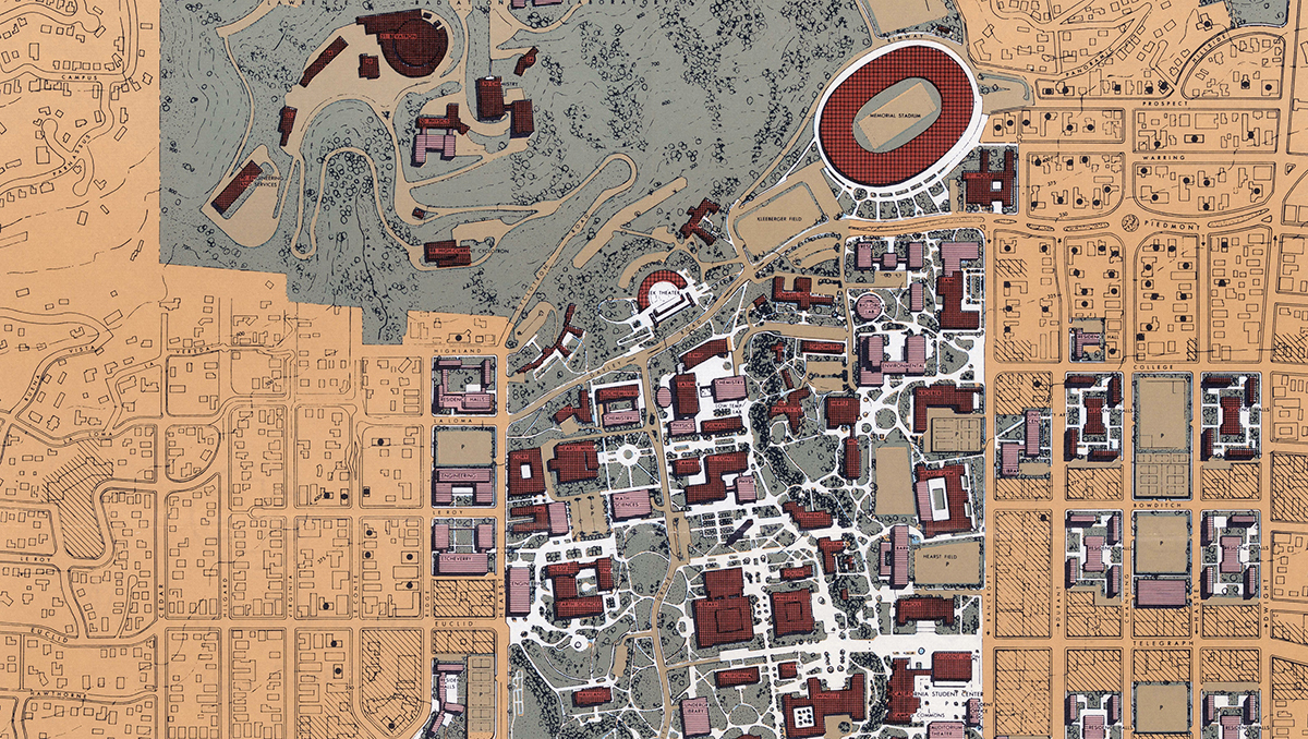
4. Best-laid plans
This 1962 map, titled Long Range Development Plan, lays out UC Berkeley’s vision for the future — or at least what a campus planning committee thought the future might look like. It’s a color-coded blueprint of buildings, landscapes, and pathways, all neatly arranged with midcentury optimism.
Some predictions came true: Evans Hall rose, as did Moffitt Library (labeled as “Math Sciences” and “Undergraduate Library” respectively). Others? Not so much. “It’s fun to see what actually got built from the long-range plan,” Powell said, “and then things that didn’t materialize.” Case in point: An engineering complex was slated for the site now occupied by the School of Journalism. Compared with the 1901 map, the 1962 plan is a leap forward, and a reminder that campus is always reshaping itself to meet the moment.

5. How to get your bearings
This 2002 walking tour map, created by staff members at The Bancroft Library, rounds up more than two dozen bears scattered across campus. We’re talking everything from stone sculptures to stuffed animals, and benches to building ornaments.
Pfeffer said the map turns bear-spotting into a scavenger hunt that anyone can enjoy. A word of caution for the curious: Most of these campus creatures still stand guard in their original spots. But others have wandered off or disappeared entirely. In 2018, the UC Berkeley Library shared a digital version of the hunt, proving that Berkeley’s bear obsession is anything but extinct.