![]()
 UCB Campus
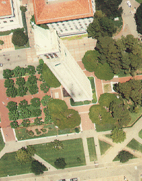
The 1994 UCB campus photography was prepared for the Physical Plant - Campus Services by Hammon/Jensen/Wallen & Associates, from an aerial survey flown by Pacific Aerial Surveys of Oakland, California. The aerial photography covers Central Campus, Clark Kerr Campus, Telegraph Avenue area and adjacent areas of the City of Berkeley.
The Map Collection has stereographic black and white contact prints (paper versions) at a scale of 1:2,400, as well as oversized enlargements at a scale of approximately 1:600. The digital images on the following pages, were originally scanned in Tiff format (courtesy of J. Kevin Hufferd) from 1:2,400 color photos. They have been enlarged to approximately 1:800, and have been converted to JPEG format for viewing online. Proceed to Graphic Interface for the Campus aerial photography.
 Return to Earth Sciences & Map Library's Home Page
![[ HELP/FAQ ]](http://www.lib.berkeley.edu/Images/helpgr.gif)
![[ CATALOGS ]](http://www.lib.berkeley.edu/Images/catalogsgr.gif)
![[ COMMENTS ]](http://www.lib.berkeley.edu/Images/commentsgr.gif)
![[ HOME ]](http://www.lib.berkeley.edu/Images/homegr.gif)